The High Tatras with an area of 341 square kilometres are the highest mountains in Slovakia and Poland. Approximately three quarters of the mountain range with its typical alpine character is situated on the Slovak side of the Carpathian Mountains. The highest peak is Gerlachovský štít (2 654 m above sea level).
The Tatra nature boasts more than 35 valleys, 31 peaks over 2,500 metres and 120 plesias. More than 600 km of marked trails allow hikers to climb to high mountain huts, difficult and less difficult peaks or pleasant walks along nature trails.
Features (2499 m) sú hraničným vrcholom medzi Slovenskom a Poľskom v hlavnom hrebeni Vysokých Tatier a patria k najnavštevovanejším tatranským vrcholom. Celkovo pozostávajú z troch vrcholov:
- middle (main) (2 503,0 m above sea level)
- north-west (2 498,7 m above sea level)
- south-eastern (2 473 m above sea level)
Tourist route
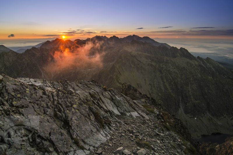
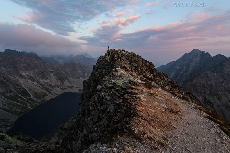
The hiking trail starts at the Popradské Pleso car park and takes 50 minutes to get to the chalet at Popradské Pleso (1 494 m above sea level). From there, a 2:30-hour route along the red trail through the Žabia valley to the chalet pod Rysmi (2 250 m above sea level) awaits us. From the chalet we then head over the Váha saddle to the highest hiking step hill Rysy. (2 499 m above sea level). This part of the route takes about 45 minutes.
Turistický výstup na Kriváň (2 494 m n. m.) je mimoriadne atraktívny a obľúbený. Kriváň je charakteristický impozantný vrch v západnej časti Vysokých Tatier. Ako symbolický vrch Slovanov a slobody Slovákov sa stal Kriváň významným motívom poézie štúrovského pokolenia a svoju pozíciu v básnickej a piesňovej tvorbe si zachoval až podnes. Od roku 1955 sú tradičné výstupy na Kriváň venované pamiatke SNP a jeho hrdinom v krivánskej oblasti.
Tourist route
There are 2 hiking trails leading to Kriváň, one of them from Štrbské Pleso. From the orientation board at the Solisko medical house, follow the red sign with a slight climb to the crossroads below the Furkotská valley, then continue along the main trail through the spruce forest, at the first crossroads continue along the red sign, at the second one turn right along the blue one. Before we turn off at the second fork we take a short walk to Jámské pleso (1 448 m above sea level). After the blue trail we climb up the Pavlovy backbone, into the rhubarb belt. A steep ascent through a debris chute will take you to the crossroads below Kriváň. This is followed by a steep ascent through Malý Kriváň to Daxnerovo sedlo and then a steep south-western slope along the rocks to the top of Kriváň (2 494 m).
The second option is the hiking trail that leads from Troch Studnički. From Troch Studnički, there is a climb up the wooded slope of Grúnik, then serpentines through the blackbrush along the back of Vyšná Priehyba (1 982 m above sea level) to the Krivánský trough. This is followed by a steep ascent through Malý Kriváň to the Daxnerovo saddle and then a steep south-western slope along the rocks to the top of Kriváň (2 494 m above sea level).
Lomnicky Peak (2 632 m n. m.) je jeden z najznámejších a najpopulárnejších štítov Vysokých Tatier a výlet na tento štít patrí k najväčším turistickým atrakciám celých Vysokých Tatier. Od r. 1940 je prístupný visutou lanovkou z Tatranskej Lomnice, čím sa stal najfrekventovanejším Tatranským vrcholom. Lanovka prekonáva výškový rozdiel vyše 1 700 m a dopravuje turistov do nadmorskej výšky 2 634 m n. m. Stanica lanovky na končiari je spojená s priestormi astronomického a meteorologického pracoviska. Hiking up to Lomnicky Peak is only allowed with a mountain guide.
Gerlachovský štít with its height of 2 655 m above sea level is the highest peak of the High Tatras, the whole Slovak Republic and the Carpathian Mountains. Gerlachovský štít is one of the most visited peaks due to its height, accessibility and beautiful mountain scenery. The starting point of the hike to Gerlachovský štít (2 655 m above sea level) is the mountain hotel Sliezsky dom. The route leads around the 15 m high Velická waterfall from the valley terrace, which earned the name Kvetnica for its botanical diversity. Hiking up to Gerlachovský štít is only allowed with a mountain guide.

Skalnaté pleso (1 750 m n. m.) patrí medzi najobľúbenejšie turistické miesta vo Vysokých Tatrách. K tomuto najobľúbenejšiemu plesu vás vyvezú dve lanovky. Z údolnej stanice v Tatranskej Lomnici 4-miestna kabínková lanovka na medzistanicu Štart, odkiaľ sa na Skalnaté pleso dostanete novou moderná 15-miestna lanovka.
Tourist route
It is also possible to go up to Skalnate pleso on foot. From the stop of the electric railway across the Path of Freedom in the direction of the Grandhotel Praha, to the valley station of the funicular to Skalnaté Pleso. Continue to the left of the funicular, enter the forest on the forest path slightly uphill. At the end, the trail passes under the cable car track and returns to the building of the intermediate station of the Start cable car by a large serpentine left. From the building the ascent is steeper and more strenuous. First we go through the forest under both cable cars, then we cross the slope for a short stretch. We cross the steep slope in the slash forest by serpentines. After reaching the crossroads, the ascent eases, we continue to the right together with the Magistrala, passing by the Skalnate chalet and reaching the Skalnate pleso (1 750 m above sea level). Total time of ascent is 1:40 hours.
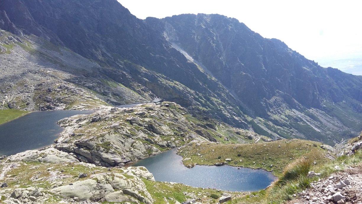
Päť Spišských plies: At the end of the Little Cold Valley, in the Basin of the Five Spišské Plies, there are five differently sized glacial lakes - the Five Spišské Plies. The highest of them is Vyšné Spišské pleso, situated at an altitude of 2022 m above sea level, while the lowest situated Nižné Spišské pleso is situated at an altitude of 1,999 m above sea level. Near Téry's chalet there is Prostredné Spišské pleso (2,010 m above sea level), which is 7 m deep. The largest in terms of area is Veľké Spišské pleso. It has an area of 3.5 ha and lies at an altitude of 2 011 m above sea level. The last fifth is the Small Spišské pleso (2 000 m above sea level).
Tourist route
Návštevníci Malej Studenej doliny a Piatich Spišských plies môžu využiť ubytovacie a sociálne služby v Téryho chate (2 015 m n. m.) a to počas celého roka. Prechádza okolo nej zelená turistická značka, ktorá vedie zo Starého Smokovca cez Hrebienok, okolo Zamkovského chaty (1 475 m n. m.) a pokračuje cez Malú Studenú dolinu. Ďalej smeruje cez Sedielko (2 376 m n. m.) až do Javorovej doliny a končí v Tatranské Javorine. Odtiaľ vedie žltá značka cez Priečne sedlo (2 352 m n. m.) na Zbojnícku chatu (1 960 m n. m.).
Veľká Svišťovka (2 037 m n. m.) je trávnato-sutinová kopa v severovýchodnom hrebeni Malého Kežmarského štítu. Pod vrcholom sa nachádza Sedlo pod Svišťovkou, kadiaľ prechádza turistický chodník Tatranská magistrála zo Skalnatého plesa ku Chate pri Zelenom plese.
Tourist route
The hike starts in Tatranská Lomnica. From there we continue 2:45 to Skalnate pleso (1 754 m above sea level). From there we follow the red marked Tatra Highway. At the crossroads below the observatory we take the left trail, which on the first section climbs steeply up to the Huncovská vyhliadka (1 800 m above sea level). Continue climbing above the lookout to the point where the trail changes from a descending to a contour trail. A long traverse along the slope of Huncovský štít (2 352 m above sea level) enhances the magnificent view of the Poprad basin and the lower mountains on the horizon. The trail crosses the Huncovská valley and ascends serpentinely to Sedlo pod Svišt'ovka (2 023 m above sea level). The beauty of the view from the saddle to the valley of Zelený pleso is multiplied if we climb to the top of Veľká Svišt'ovka (2 038 m above sea level). After returning to the saddle, we will descend the shady slope along the trail with countless serpentines. After the last serpentine we turn left and through the slash-trees along the Black Pleso we will reach the Green Pleso.
Eastern High (2 428 m n. m.) je turisticky veľmi významný vyhliadkový štít v hlavnom hrebeni Vysokých Tatier. Čnie sa nad troma dolinami: Velickou, Veľkou Studenou a Bielovodskou dolinou (nad časťou Zamrznutý kotol Svišťovej doliny). Z vrcholu je prekrásny výhľad na celé Tatry. Náročnosť: Veľmi namáhavá túra s veľkým prevýšením. Jedna z najdlhších a zároveň najkrásnejších v Tatrách. V oblasti Poľského hrebeňa sú často letné snehové polia! Technicky je náročnejší iba zostup z Poľského hrebeňa, ktorý je zabezpečený reťazami.
Tourist route
From Tatranská Polianka you can reach Sliezsky dom (1 670 m above sea level) in an hour. Then we continue along the eastern shore of Velicky pleso to the rocks called Eternal Rain. The next stretch of the road follows the grassy valley floor and climbs gently past the Round Hill to Dlhý pleso. To the left, Krčmar's trough - one of the longest troughs in the Tatras - stretches above the lake. The path ascends gently until you reach the Polish Ridge (2 000 m above sea level). The route from Sliezský Dům to the Polish Ridge takes an hour and you should be prepared for chains. From the Polish Ridge we then have a 45-minute hike to the East High (2 428 m above sea level).
Predné Solisko (2 093 m above sea level) is the last elevation of the long Solisko Ridge, which rises from the Furkotský Peak towards the southeast. Predné Solisko is a nice scenic peak, which is reached by a hiking trail from the Chalet pod Solisko. A ski lift was built on its southeastern slopes in 1943 - the first in the High Tatras and the second in Slovakia. Today, thanks to the excellent terrain, there is an excellent downhill track from Chata pod Solisko to the ski area at Štrbské Pleso.
Tourist route
From Štrbské Pleso (1 346 m above sea level) (sports complex) there is a hiking trail along the Solisko Ridge to the Chata pod Soliskoom, on the right side there is a chairlift. From the chalet there is a climb up several serpentine steep rocky slopes to the very top. The total time of the route from Štrbské pleso to Predné Solisko is 2:30 hours.

Ostrva (1 926 m above sea level) is a sprawling peak at the end of the lateral south-western ridge of Končiste. The Tatra Highway passes through the saddle below Ostrva in front of the inconspicuous peak. It is a lookout point from which there is a beautiful view of the Mengusovská valley and Zlomísk. Poachers and hunters have always known the slopes of Ostrva. The present section of the highway was built between 1930 and 1931. The Symbolic Cemetery is located in the limbus grove at the foot of the highway.
Tourist route
You have to go to the peak from the Popradské pleso car park, where you can reach the chalet at Popradské pleso (1 494 m above sea level) in 50 minutes. Then long serpentines await us, which will lead us to the saddle below Ostrva. The saddle is located close to the summit (1 984 m above sea level). This part of the route takes about an hour.
Kôprovský štít (2 363 m above sea level) is a prominent peak, the first in the Krivánské Rázsocha, which rises from Čubriny. A hiking trail leads to the summit from the Vyšná Kôprovský sedlo (Higher Kôprovský Saddle). The view from the peak is magnificent. Nearby is the Great Hincovo pleso. Poachers and hunters have been moving along the slopes of the peak since time immemorial. The beginnings of its mountaineering history date back to the times around 1880, in the winter of 1906.
Tourist route
You have to go to the peak from the Popradské pleso car park, where you can reach the chalet at Popradské pleso in 50 minutes. Then we will follow the red sign for 35 minutes, where at the crossroads we will change to the blue sign, which will lead us after about an hour to the largest lake in the Tatras, the Big Hince Mountain (1 944 m above sea level). After seeing the Great Hincovské pleso, we will continue on for about 1:15 h., where we will cross the Vyšné Kôprovské sedlo (2 180 m above sea level) to reach the summit, which is located at an altitude of 2 363 m above sea level.
The Jahňací Peak (2 230 m above sea level) is the easternmost peak of the High Tatras. The view from Jahňací Pleso offers a view of Lomnický and Ľadový štít (to the south-west), the end of the valley of Kežmarská Bielej voda, the ridge of the Belianske Tatras and Spišská Magura (to the east).
Tourist route
The route starts at the bus stop or at the parking lot Biela voda, from where you can follow the yellow trail to the Chata pri Zelenom Pleso (1 551 m above sea level) in about 1:50 hours. From the chalet you will have a difficult 2-hour climb, which will take you up to Jahňací štít (2 230 m above sea level).
Slavkovský štít (2 452 m above sea level) is a popular sightseeing peak for tourists and it has a wide, sprawling summit at the end of the south-eastern spur that runs out from Východná Vysoká. Chamois hunters have long roamed the slopes of Slavkovský štít.
Tourist route
From Starý Smokovec we will head north along the blue trail. Soon turn left and follow the forest path slightly up, passing by Five Springs to the crossroads on the Tatra Highway. Continue along the forest trail and take a long traverse to the right up to the upper end of the ski trail. In a short while we will find ourselves on the Slavkovská prospect (1 550 m above sea level). From the lookout we continue left, first in the sagebrush, then in the open terrain, serpentinely up the southern slope, then along the ridge called the Stubbly Ridge, below the Slavkovský Nose (2 273 m above sea level), the summit of the Slavkovský Peak. We go around the nose from the right and climb another serpentine to the top of Slavkovský štít (2 452 m above sea level). It is a long and difficult climb with a high altitude, which takes more than 4 hours.
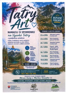
Cover photo: Rysy, author: Jano Štovka, MQEP


