

Features (2 499 m above sea level) is an iconic peak of the Tatra Mountains located in their main ridge on the Slovak-Polish border. They are attributed with many firsts - the highest mountain in Poland, the highest border crossing, the most visited and highest mountain in the Tatras, which can be reached by a common tourist on his own feet without using a cable car or a mountain guide.
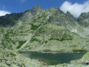
The features have three peaks: the northwest (border), the middle (main) and the southeast (lowest). At the foot of the Slovak side of Rysy there is a set of three lakes called Frog Pleso, which are a great intermediate stop when climbing to the summit.
From the top parts of Rysy, after a rather difficult ascent, you will have a beautiful view of the whole panorama of the Tatras, which is the reason why many tourists from Slovakia and abroad come here. Rysy simply has its unique charm, which every Tatra tourist must experience.
Ascent to Rysy is definitely an experience not to be missed. Because it is one of the most beautiful mountain hikes in the High Tatras. The route climbs from Štrbské Pleso past Popradské Pleso and Chata pod Rysmi through several exposed sections to the top. The path to the top will take you past mountain rapids and through paths secured with chains.
Rysy is one of the six peaks of the Tatras accessible by hiking trail and the 9th highest peak of the High Tatras.
Rysy (2499 m) is a border peak between Slovakia and Poland in the main ridge of the High Tatras with three peaks:
- lookout 2 503 m above sea level (border), which is the Slovak-Polish border.
- north-western, middle 2 498 m above sea level (main) - it is the highest peak in Poland
- southeastern, the lowest 2 472 m above sea level on the Slovak side of the Tatras.
Three ridges rise from the summit: north to Maly Rysy, south across the Váh to Český štít and west to Žabí koň. Rysy is one of the most visited peaks in the Tatras. For the wide view they provide. For ordinary hikers, Rysy is the highest point they can legally reach in the High Tatras without a mountain guide. From the top you can see Morskie oko and Czarny staw in Poland.
On the slopes of the Rysy Mountains there is the highest mountain chalet in the Tatras and in Slovakia, Chata pod Rysmi (2 250 m above sea level), which is open to tourists only during the summer tourist season and in winter there is a winter closure.
You can reach Rysy from the Chata pri Popradskom plese (blue sign) to the Crossroads Nad Žabím potokom and from there continue around the Frogs' Plies to the Chata pod Rysmi, to the Váha saddle and from there turn left to the top of Rysy (red sign). The hike is more demanding with a high altitude and requires better fitness.
[gallery:12]For pedestrians:
An interesting day hike for hikers in good condition. Starting from the Popradské pleso stop, we will take the asphalt road to the Chata Pri Popradskom plese, 1h (blue trail). We can rest here for a while and refresh ourselves. If we have enough strength, we can take a lift from the Crossroads at Popradské pleso to the Chata pod Rysmi. From Popradský pleso we go 0.30 h (blue mark) to the Crossroads above the Frog Brook along the forest path with stones, so far we climb gently. From the crossroads we continue in the direction of Chata pod Rysmi (red). Here the ascent is quite a bit more pronounced, we slowly gain altitude by walking on serpentines on the stone path. The ascent is long, but not boring. Along the way we see the Frogs' Pale, a little beyond it we are faced with exposed terrain secured with chains, crampons and metal grates. A slow climb will take us up to the highest hut in the High Tatras - Chata pod Rysmi. This also provides the possibility of refreshment and rest. From the chalet we will go to the saddle of Váha, to the very top of Rys we have only 0.45 h. We will have beautiful views of Morskie oko and Czarny staw on the Polish side of the Tatras, as well as the beautiful panorama of the High and Western Tatras.