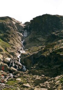
Height: 80 m Width: 1.5 m
Altitude: 1245 m above sea level
Origin: glacial, selective and tectonic
Location.
Flow: Necferský brook
Access:
- from Troch studnički along the blue marker; from Podbanský along the red marker, then along the blue marker to Kôprová dolina
- hiking trails: [Temnosmrečinské plesá from Troch Studničky], [Kôprovský štít from Troch Studničky], [Hladké sedlo from Troch Studničky]
Interesting facts:
Kmet'ov waterfall is the highest waterfall in the Tatras with a height of 80 m.
The waterfall is named after the well-known Slovak nationalist, botanist and co-founder of the Slovak National Museum in Žilina, Andrej Kmet'o.
Despite its uniqueness, Kmet'ov Waterfall is not very well known among tourists - it is not on the main tourist routes.
Direct access to the waterfall is prohibited.
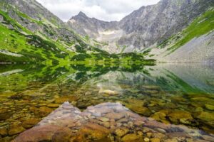
The Kôprová valley is a long wooded valley on the southern side of the High Tatras.
There are two explanations for the name of the Dill Valley: one is that the name derives from the German word "Kupfer", which translates to copper - which was mined in this area in the past. The second version of the explanation of the origin of the name of the picturesque valley is related to a plant that is abundantly found in the area and its name is Dill.


