

Bachureň je najvyšší vrch rovnomenného pohoria, ktoré je ešte nižším pohorím než susedné Branisko, od ktorého ho oddeľuje Lačnovské sedlo. Rozkladá sa na severovýchodnom Slovensku v častiach okresov Sabinov a Prešov.
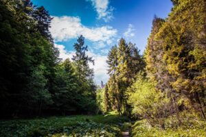
Bachureň is a forested mountain with many meadows and pastures, which offer opportunities for pleasant and easy hiking, cycling in the lap of beautiful nature with magnificent views of the surrounding countryside.

One of the most visited destinations of this flysch mountain range is its highest mountain of the same name, which rises at an altitude of 1 081 m above sea level Its charm lies in the distinctive landscape relief, where relatively well-preserved forests alternate with wide meadow passages.
The summit is overgrown with thickets on one side, but offers limited but distant views. Several neighbouring mountains are easily observable from suitable locations outside the surrounding hills. A truly beautiful view of the High Tatras, adjacent Branisko with the dominant Spruce, Levoca Hills a the valley of Čierny Močiar. In addition to the views, there is also wooden benchso that you can not only enjoy the magic, but also to relax and recharge your batteries.

The hill is accessible by marked hiking trails leading from the villages of Nižný Slavkov, Vyšný Slavkov or Lačnov to Sedlo pod Bachurňou.
Najvyšší vrch rovnomenného pohoria Bachureň ponúka nádherný panoramatický výhľad. Na Bachureń sa dostaneš viacerými trasami, je to len na tebe.
For pedestrians: Najvyšší vrch rovnomenného pohoria Bachureň ponúka nádherný panoramatický výhľad. Na Bachureň sa dostaneš viacerými trasami, je to len na tebe.
Access:
- along the green marked hiking trail:
- from Sabinov via Marduňa (873 m above sea level) and Javor (931 m above sea level)
- from the settlement of Lačnov via the Magura and Bachureň saddle
- along the red marked route:
- from the village Hermanovce via the Buče hill (1 005 m above sea level) and the Bachureň saddle (connection to the green trail)
- from Nižný Slavkov via the Bachureň saddle
- on the yellow trail from Renčišov through the Buče saddle (connection to the red trail)
Pre cyklistov: Z osady Lačnova sa na Bachureň môžete dostať bicyklom cez lesnú cestu.
- Start: Lačnov - Lipovce
- Objective: Bachureň
- Length of route: 3 km
- Duration: 0:30 h
- Elevation: ⇗ 303 m n. m. ⇘ 0 m n. m.
- Surface: Forest path
- Link mapy.cz: <iframe style="border:none" src="https://sk.frame.mapy.cz/s/fudekevazu" width="400" height="280" frameborder="0"></iframe>


year-round