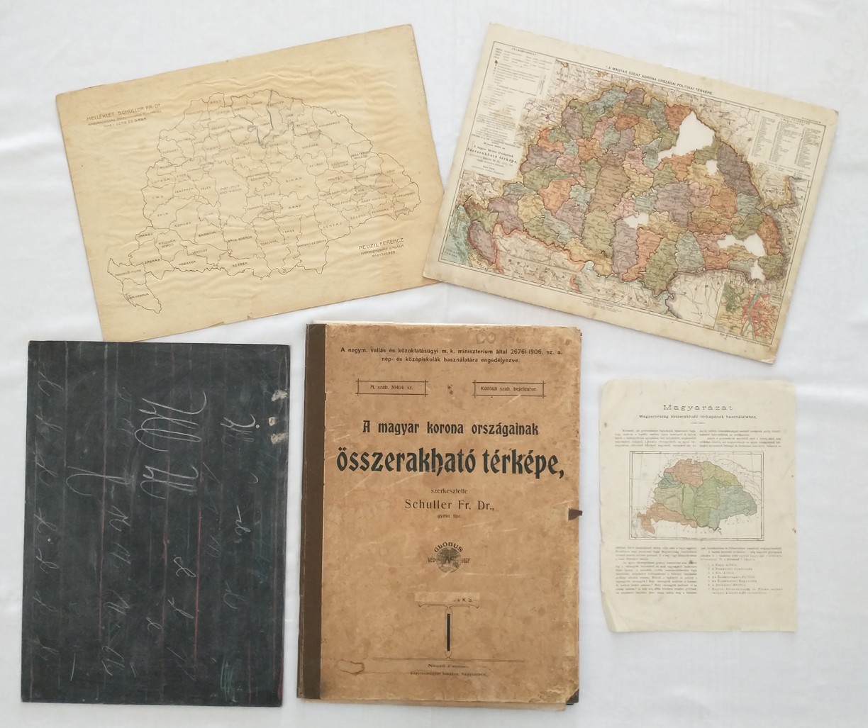
When new objects arrive at the museum, the experts often discover objects that surprise them literally and literally. In 2015, among the future exhibits were worn boards that, at least according to the Hungarian inscription, were supposed to contain some kind of geographical map.
After their opening, a pleasant surprise awaited the museum visitors. There was indeed a map of Hungary with the individual counties, but its design was most unusual. It was in the form of a jigsaw puzzle with a mat where the individual pieces were placed. It was made of hard cardboard with dimensions of 43.4 x 31.6 cm. In addition, the interior consisted of a separate sheet with the division of the counties, a legend with their distribution into individual districts, and a hard board for writing in chalk.

Let's take a closer look at the puzzle itself. On the internet we can read that the roots of the popular jigsaw puzzle go back to around the end of the 17th century. It was invented by British cartographer and engraver John Spilsbury, originally as a geographical teaching aid. In a sort of interactive way, children had to determine the location of the states at the time by finding the correct hole. The first puzzles were, of course, made of wood. It took some time for this innovation to penetrate into our area.
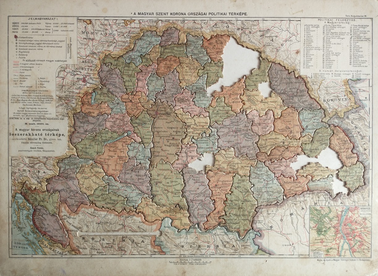
The official title of the museum object is Folding Map of the Countries of the Hungarian Crown. It was compiled by the gymnasium teacher Dr. Fr. Schuller, published by Ferenc Neuzil in today's Romanian town of Sibiň (Sibiu). The exact year of publication is not known, but it can be dated to the period 1906-1914. The purchase price was three crowns.
The 1:2400000 scale puzzlemap originally contained 71 multi-coloured pieces. Unfortunately, the puzzle is not complete. Seven pieces are missing, namely the counties of Zemplín, Už, Ugoč, Čanad, Malokykul and Udvarhelya. The first legend is located in the upper left year, dedicated to explaining the colours, markers and size of the towns. On the opposite side are listed the different counties, divided according to the political division between Hungary proper and Croatia-Slavonia, at the time of the publication of the teaching aid an autonomous kingdom within the monarchy (63 + 8 counties). On the lower right is a plan of Budapest, the capital of the country.
The fact that this is a meticulous work is evident from the fact that each piece has a separate text on the back, where the most important facts about the county are listed. Let's focus more on our Spiš County. We can find the towns of Stará Ľubovňa, Podolínec, Spišská Bela, Kežmarok, Poprad, Levoča, Spišská Nová Ves, Spišské Podhradie, Krompachy or Gelnica. All of them in the contemporary Hungarian version. Among the mountains is Magura, the highest mountain of the monarchy is also marked - Franz Joseph's Peak, currently called Gerlach Peak. It was named after the Hungarian king and Austrian emperor between 1894 and 1919.
On the opposite side of the piece is the most important information about the county. Spišská had an area of 3 668 km 2 and was inhabited by approximately 172 252 people. The most important mountain range was the High Tatras, the Hornád, Poprad and Dunajec rivers flowed through it. Štrbské pleso was also part of the watershed. The county seat was Levoča with a population of 7 486 people, an important monument was the Thököly manor house (!) in Kežmarok, and Smokovec was a tourist and spa stop.
This unique exhibit fulfils its original, educational purpose even a hundred years after its publication. During the processing of the object itself, as well as during the writing of the article, the jigsaw puzzle inadvertently "managed" to fall apart, so it had to be reassembled. And twice for sure! At least this way one got to know the division of the counties of our former monarchy more closely.
This school tool is currently not publicly accessible to visitors, it is stored in the Kežmarok museum depository. However, the Kežmarok in the 19th and 20th Century exhibition is currently being reinstalled, so it is possible that the puzzle will eventually appear there.
If anyone is interested in more photographs or information, they can contact the author of the article or the curator of the collection at historik@kezmarok.com .
Author: Vladimír Julián Ševc
Author of photo: Museum in Kežmarok


